Ward 10 Residents · Stoney Creek · Hamilton
Rezoning Application Submitted
One Way Path has now submitted its request to amend the zoning for 520 Highway 8 in Stoney Creek. Residents should send written comments directly to James Van Rooi by Friday, May 15 so they are included in the official record for file DPA-2026-00023.
What residents should do now
- Review the current status of the rezoning application
- Personalize the planner email template with your concerns
- Send written comments to City Planning Staff by Friday, May 15
- Share this page so more neighbours submit formal comments in time
Step 2
Current Status
The proposal has moved from the concept and open-house stage into the formal City planning review stage. Residents should now send written comments directly to James Van Rooi so they are included in the official record for file DPA-2026-00023.
Project stage
Formal review is underway
One Way Path has submitted its rezoning and development application for 520 Highway 8. The file is now with City Planning Staff for review.
Application file
DPA-2026-00023
Use this file number when writing to the City so your comments are tied clearly to the 520 Highway 8 application.
What staff review
Reports, studies, and technical material
City Planning Staff will review the application package, supporting reports, and agency comments before making a recommendation.
Deadline
Send comments by Friday, May 15
Written comments sent to James Van Rooi are added to the official planning record and are the most immediate action residents can take right now.
Step 3
Take Action
The priority now is sending formal written comments to City Planning Staff before Friday, May 15. Use the planner email template first, then support it with the petition or any direct questions you want to raise with the developer.
Send Your Comments To City Planning Staff
This is the most important action residents can take right now. Personalize the template below, send it to James Van Rooi, and reference file DPA-2026-00023.
Comments sent now become part of the official public record.
- Planner
- James Van Rooi
- Title
- Senior Planner, City of Hamilton
- James.VanRooi@hamilton.ca
- Project
- 520 Highway 8, Stoney Creek
- File
- DPA-2026-00023
Personalize this email before sending it. Specific details about your home, street, family, and daily experience carry more weight than a generic message.
- Subject
- Concerns Regarding 520 Highway 8 Rezoning Application – DPA-2026-00023
Dear Mr. Van Rooi,

I am writing regarding the rezoning application for 520 Highway 8, Stoney Creek, file DPA-2026-00023.

I am concerned that the proposed development is too large for this site and is not compatible with the surrounding neighbourhood.

My concerns include:

[Add your personal concerns here -- traffic, parking, privacy, shadowing, construction impacts, excavation, safety, neighbourhood character, impact on the Escarpment area, or other issues.]

I ask that the City carefully review whether this proposal is appropriate for this location and whether it conforms with the existing planning framework for the area.

Please include my comments as part of the official public record for this application.

Sincerely,

[Your Name]
[Your Address or Neighbourhood]
- height and scale
- traffic at Highway 8 and Dewitt Road
- parking and overflow parking
- construction impacts
- excavation impacts on nearby homes, pools, foundations, and basements
- privacy and overlook into backyards
- shadowing and loss of sunlight
- noise, dust, and safety
- school-zone impacts
- compatibility with the surrounding neighbourhood
- the south side of Highway 8 is within the Niagara Escarpment Area Plan urban area and is considered a scenic corridor, especially at the main cross sections of Fruitland Road, Dewitt Road, Millen Road, and Green Road
- whether the City should require more complete technical information before considering approval
- whether the applicant has the financial and technical capacity to complete a project of this scale without leaving a stalled or incomplete site
If you raise the last point, frame it as a due-diligence concern: the City should consider whether the applicant has the financial and technical capacity to complete a project of this scale, so the neighbourhood is not left with a stalled or incomplete development.
Paste any of these into the template and edit them so they reflect your own concerns.
The proposed height and scale are not compatible with the surrounding low-rise neighbourhood.
I am concerned about increased traffic and safety impacts at Highway 8 and Dewitt Road.
I am concerned about privacy, shadowing, and overlook into nearby backyards.
I am concerned about excavation and construction impacts on nearby homes, foundations, pools, and basements.
The south side of Highway 8 is within the Niagara Escarpment Area Plan urban area and is considered a scenic corridor, especially at the main cross sections of Fruitland Road, Dewitt Road, Millen Road, and Green Road. The views of the Escarpment driving south toward these main intersections are something we cherish and should protect for future generations. The current zoning does this.
I ask the City to require complete technical studies before considering any approval.
Recent signatories:
- ✓ Vanja Kajic Jun 28, 2026
- ✓ Anonymous Jun 1, 2026
- ✓ Anonymous May 18, 2026
- ✓ Anonymous May 15, 2026
- ✓ Fiona Petit May 14, 2026
- ✓ Anonymous May 14, 2026
- ✓ Anonymous May 13, 2026
- ✓ Anonymous May 12, 2026
- ✓ Anonymous May 11, 2026
- ✓ Anonymous May 11, 2026
Email the Developer
If you want to raise direct questions with One Way Path, you can still use this template. The most important formal step, however, is emailing City Planning Staff before Friday, May 15.
Personalize the highlighted section before sending.
- To
- One Way Path Communities
- info@onewaypath.com
- Subject
- Community Concerns Regarding Proposed Development at 520 Highway 8, Stoney Creek
Dear One Way Path Communities,

I am a resident of Ward 10 writing to share my concerns regarding your proposed 11-storey purpose-built rental development at 520 Highway 8 in Stoney Creek.

I understand that housing is needed in our community. However, I am concerned that this proposal does not align with the existing planning framework for this site, including the Urban Hamilton Official Plan, the Western Development Area Secondary Plan, and the current C2-579 zoning designation.

--- MY PERSONAL CONCERNS AND QUESTIONS ---

[Please replace this section with your own concerns. For example: how will this affect traffic on your street, views from your property, parking availability, the character of your neighbourhood, or anything else you want the developer to address directly. Your personal experience carries real weight.]

--- END OF PERSONAL SECTION ---

More broadly, I and many of my neighbours are concerned about:

  - The proposed height and density relative to the surrounding low-rise neighbourhood
  - The compatibility of an 11-storey building with the established character of the Highway 8 corridor
  - The relationship of this site to the Niagara Escarpment Plan area and the requirement for visually compatible development
  - Potential traffic and infrastructure impacts at an already constrained intersection
  - The precedent that approving a development of this scale may set for future applications in the area

I encourage One Way Path Communities to:

  1. Engage openly and directly with Ward 10 residents and meaningfully consider community feedback
  2. Explore design revisions that bring the proposal into conformance with the existing planning framework
  3. Provide clear public information on how the proposal addresses traffic, infrastructure, and Escarpment compatibility
  4. Consider a scale of development that reflects the character and context of this neighbourhood

You can learn more about the community's concerns and read our petition at https://www.ward10residents.ca.

I appreciate you taking the time to read this message and I look forward to your response.

Sincerely,
[Your Name]
[Your Address, Stoney Creek]
Step 4
Understand the Proposal
One Way Path Communities has now submitted the rezoning application for 520 Highway 8 in Stoney Creek. The file is proceeding through formal City review as DPA-2026-00023, following the earlier Community Open House held on March 12, 2026.
- Location 520 Highway 8, Stoney Creek — frontages on Highway 8 (north) and Dewitt Road (east)
- Site Area 0.32 hectares (0.79 acres)
- Proposed Use Purpose-built rental residential with 453 m² of active commercial space at ground level
- Proposed Height 11 storeys + mechanical penthouse
-
Proposed Units
161 purpose-built rental units:
- 118 × 1-bedroom (73%)
- 32 × 2-bedroom (20%)
- 11 × 3-bedroom (7%), including 5 street-level townhouses on Dewitt Road
- Parking 103 vehicle spaces • 92 bicycle spaces
- Developer One Way Path Communities
- Application Status Formal City planning review underway — File DPA-2026-00023
- Current Zoning C2-579 — Neighbourhood Commercial (Exception 579)
- Parent Zoning By-law 05-200 — amended by By-law 17-240
- Site-Specific Exception 579
- Related OPA UHOPA 69 ⚠️ We are looking for a link to the active Official Plan Amendment on this property — if you have it, please share it.
- Council Approval October 25, 2017
- Final Binding Date November 23, 2018
- OLT Case PL171450
- Temporary Uses T6, T8 — active until February 28, 2027
- Community / Zoning Maps Stoney Creek — Maps 1305, 1306
The proposal significantly exceeds what is permitted under the current C2-579 zoning. The table below shows the key gaps. Each gap requires a formal amendment.
| Regulation | Current Zoning (C2-579) | Proposed Development |
|---|---|---|
| Maximum Height | 11 m (≈ 2–3 storeys) | ~32–36 m (11 storeys + penthouse) |
| Primary Use | Community commercial (retail, services, offices; limited residential possible) | Predominantly residential apartment building with ground-floor retail |
| Lot Coverage | Typically ≤50–60% of lot area | Substantially higher — building occupies most of the corner footprint |
| Building Massing | Low-rise commercial form with setbacks | Large continuous mid-rise street wall |
| Density / Units | Neighbourhood-scale commercial uses | 161 purpose-built rental units |
| Parking | Based on floor area / units per by-law | 103 vehicle spaces proposed (may require variance) |
Approvals Required
- Submitted Official Plan Amendment (OPA) — required because the proposed density and height exceed the current Official Plan designation
- Submitted Zoning By-law Amendment (ZBL) — required because the proposed height, density, and use exceed what is currently permitted under the Zoning By-law
- Required Site Plan Approval (SPA) — the detailed design review stage, typically required for all significant developments
Developer’s Summary Handout
Distributed at the Community Open House, March 12, 2026.
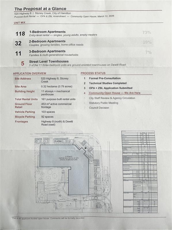
Click to enlarge.
Urban Hamilton Official Plan — Western Development Area Secondary Plan
This land use map (Map B.7.1-1, effective August 16, 2013) shows the planning designations in the area. The 520 Highway 8 site (marked F) is designated Local Commercial — consistent with the existing C2-579 zoning and surrounding low-density residential development.
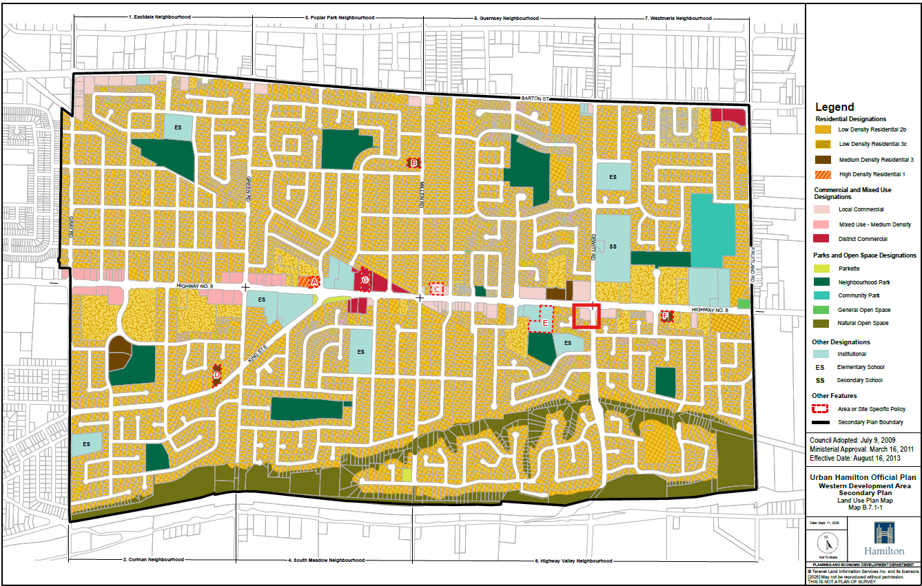
Click to enlarge. Source: City of Hamilton Planning and Economic Development Department.
Step 5
How the Process Works
Understanding the planning approval process helps residents identify the stages where their participation is most effective. The steps below reflect the typical process for a development application requiring amendments in Ontario.
✓ Formal Pre-Consultation
The developer met with City planning staff before filing a formal application to discuss the proposal, identify issues, and determine required studies.
Completed✓ Technical Studies Completed
Supporting studies — including planning justification, traffic impact, environmental, and servicing reports — were prepared by the applicant's consultants.
Completed✓ OPA + ZBL Application Submitted
The developer filed a complete application package — including drawings, planning studies, and supporting documents — to the City of Hamilton. The application is now a public record.
Completed✓ Community Open House
An applicant-hosted open house was held on March 12, 2026, where residents could learn about the proposal directly from the developer's team. Comments submitted at the open house are formally recorded and submitted to the City.
Held March 12, 2026📢 City Staff Review & Agency Circulation
The City circulates the application to internal departments (engineering, transportation, parks) and external agencies (Conservation Hamilton, Niagara Escarpment Commission, utilities). Each provides comments and conditions that the applicant must address. Written comments from residents sent to James Van Rooi become part of the official planning record during this stage.
In progress — we are here📢 Statutory Public Meeting
A formal public meeting is required under Ontario’s Planning Act. This is held at City Council or a Committee of Council. All residents have the right to speak as a delegate and to submit written comments for the official record.
Key opportunity for resident input🏛️ Council Decision
Elected councillors review the staff report, hear delegations, and vote. Residents may delegate at both the committee and council stages. Petitions and letters submitted earlier to City Planning Staff help shape the record at this stage. After a decision, any party who participated formally may appeal to the Ontario Land Tribunal (OLT).
Key opportunity for resident inputStep 6
Concerns and Possible Solutions
The following concerns have been raised by Ward 10 residents regarding this proposal. For each concern, we have also identified potential ways it could be addressed through the planning process.
Our goal is to help shape a development outcome that is beautiful, useful, and something Ward 10 can be proud of — provided community needs and planning requirements are genuinely respected.
At approximately 11 storeys, the proposed building significantly exceeds the height of surrounding structures, which are generally 2–3 storeys. The transition in scale would be abrupt and visible from much of the surrounding neighbourhood.
Possible Response
Height could be stepped down toward neighbouring properties; podium massing, architectural setbacks, and design standards can reduce perceived visual impact. The City’s urban design guidelines can be applied as conditions of approval.
The Fruitland / Dewitt Road area already experiences significant congestion during peak hours. A building of this scale would introduce hundreds of new vehicle trips daily, compounding existing issues at a challenging intersection.
Possible Response
A traffic impact study is a mandatory submission requirement. Road improvements, turning lanes, intersection modifications, or contributions to transportation infrastructure can be required as conditions of approval.
If this proposal is approved with Official Plan or Zoning By-law amendments, those approved parameters become a reference point for future applications. The character of the neighbourhood could change incrementally through a series of precedent-setting approvals.
Possible Response
Site-specific zoning exceptions limit the precedential impact. A comprehensive secondary plan review for the area would provide a clearer policy framework and reduce the risk of ad hoc precedent-setting.
Local water, sanitary sewer, and stormwater infrastructure may not have been designed to accommodate the load that an 11-storey building with hundreds of units would generate on existing systems.
Possible Response
Functional servicing and stormwater management studies are required as part of any application. Required infrastructure upgrades can be secured as financial contributions or physical works required of the developer.
The visual identity and physical character of the Fruitland / Dewitt Road area has developed around a lower-density residential pattern. A high-rise building at this location would materially alter that character.
Possible Response
Urban design conditions, exterior material standards, landscaping and setback requirements, and compatibility studies can all be applied at the site plan stage to ensure new development is designed to respect its surroundings.
Major development applications that require amendments create an opportunity to negotiate community benefits that the neighbourhood would not otherwise receive. This is an underused but legitimate part of the planning process.
Possible Outcome
A development agreement or community benefits framework could include community amenity space, streetscaping improvements, accessible rental units, active transportation connections, or contributions to local parks and green space.
⛰️ Niagara Escarpment Area Plan — Where Is 520 Highway 8?
The map below shows the Niagara Escarpment Area Plan boundary (red outline). The Highway 8 corridor through Stoney Creek and Fruitland is a designated scenic corridor within the Escarpment Area Plan. While the Niagara Escarpment Commission does not issue Development Permits for urban zones, the scenic corridor designation and Escarpment Area Plan policies must still be considered in any planning review. A proposal of this height and massing on a prominent corner of a designated scenic corridor raises legitimate compatibility concerns.
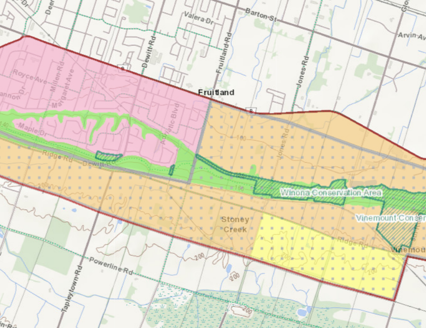
Click to enlarge. Source: Niagara Escarpment Area Plan.
Step 7
Planning Context
The file is now active, but the existing planning framework still matters. Use the documents and references below to understand what is currently permitted and what the application is asking the City to change.
Ward 10 Overview
Ward 10 covers the Stoney Creek area of Hamilton, encompassing established residential neighbourhoods near the lake, newer suburban development, and agricultural land at the escarpment. The Fruitland / Dewitt Road area sits between established residential and the base of the Niagara Escarpment.
Niagara Escarpment Area Plan
The Niagara Escarpment is a UNESCO World Biosphere Reserve governed by the Niagara Escarpment Plan (Province of Ontario). Land near the escarpment is subject to policies that protect its natural environment, visual character, and ecological function. Development proposals in this area must demonstrate compatibility with these provincial policies.
Hamilton’s Official Plan
Hamilton’s Official Plan establishes the long-term vision for land use across the city, including policies on residential density, built form, intensification areas, and neighbourhood character. Secondary plans may also apply to specific areas of Ward 10, providing more detailed guidance on appropriate development.
- 🔗 Urban Hamilton Official Plan
- Official Plan Policy Documents
- 📄 Vol. 1 Chapter B — Communities (Nov 2025)
- 📄 Vol. 1 Chapter F — Implementation (Feb 2026)
- Stoney Creek Secondary Plans
- 📄 Chapter B.7 — Stoney Creek Secondary Plans (Feb 2026)
- 📄 Map B.7.1-1 — Western Development Area (Sep 2025)
Property-Specific Zoning
The property at 520 Highway 8 is subject to zoning designations under Hamilton’s Zoning By-law that determine permitted uses, maximum building height, setbacks, and parking requirements. Any proposal that exceeds or conflicts with these permissions would require a formal Zoning By-law Amendment.
City of Hamilton Planning Resources
The City of Hamilton provides public access to planning applications, mapping tools, zoning information, and development activity. These are the authoritative sources for tracking any application at 520 Highway 8 as it progresses through the system.
Related News
Recent reporting on housing, intensification, and development trends can help residents understand the broader context around proposals like 520 Highway 8.
Why Context Matters
Understanding the planning framework before reacting to a proposal allows residents to ask more effective questions, make stronger representations, and engage more constructively with the process. The planning system is designed with public participation in mind — using it well makes a difference.
Stay informed as the planning application progresses.
Share this site with your neighbours so more Ward 10 residents stay engaged and informed.